Spatial domain
Spatial domain represents 2D or 3D area definition in the dataset. Spatial domain definition is not updatable.
Supported 2D formats
Grid (raster) data
- Regular rectangular grid
- Not equidistant spatial axis
Mesh data
Mesh elements can be triangles or quadrilaterals
3D layered data (Vertical domain)
Verticality is supported using layers. It is not true 3D element geometry. Vertical layers are supported for all supported 2D formats.
Static vertical layers
The vertical layer is not changing over time and is defined by vertical transformation
Supported formats: - Equidistant layers - Not equidistant layers
Variable vertical layers
The layer positions are defined for each timestep as in combined sigma-z.
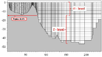
Each layer is stored separately - see Design and structure
Temporal domain
Both equidistant and non-equidistant temporal definition are supported
Time stamp normalization
Time stamps are rounded to the nearest millisecond. Source files (NetCDF, GRIB, …)
often store the time axis as a number of hours or days since a reference date, which can
introduce tiny rounding errors of a fraction of a microsecond — so a clean hourly axis
might otherwise appear as 20:00:00.0000002 or 21:59:59.9999997.
Rounding removes these artifacts, so that:
- time stamps are reported as clean values, and
- a regular (equidistant) axis is correctly recognized as such.
Items (variables)
Items (variables) definition:
NameType- value datatype (float,double,...)Quantity- defined by DHI.EUMItemId(e.g.eumIWaterDepth) andUnitId(e.g.eumUmeter)NoDataValue- value for undefined, missing, or not available data value